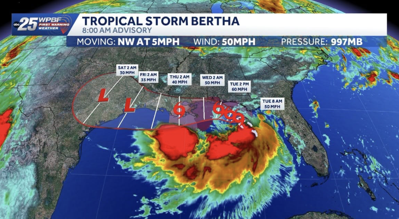
Sandy Springs faces a heightened risk of flash flooding Wednesday, July 22, as moisture from Tropical Storm Bertha collides with a stalled cold front over North Georgia.
The National Weather Service's Peachtree City office issued a Hazardous Weather Outlook for Fulton County, including Sandy Springs, warning that storms could dump heavy rain across the metro area. The NWS listed Atlanta under a level 2 risk of excessive rainfall (on a scale of 1 to 4) as of Wednesday morning, according to reporting by the Augusta Chronicle citing NWS data.
The danger window: storms are most likely after 3 p.m. Wednesday and before midnight, according to the NWS Sandy Springs forecast. The agency calls for a 30% chance of showers and thunderstorms Wednesday afternoon, rising to 40% Wednesday night.
What's driving the threat
Tropical Storm Bertha itself is not headed for Georgia. As of 8 a.m. Wednesday, the storm sat off the coast of Pascagoula, Mississippi, moving slowly westward toward Louisiana, according to the National Hurricane Center.
But Bertha's moisture is streaming northward and slamming into a cold front stalled over the Appalachian Mountains. The NWS Peachtree City office said on Tuesday, July 21, that this combination supports "training" storms — repeated rounds of heavy rain tracking over the same areas — across the northern half of its forecast area. The NWS warned that areas of Atlanta already prone to flooding could see significant water buildup.
NWS Meteorologist Meredith Wyatt told Patch on Monday, July 20, that Bertha was expected to continue pushing westward but would increase moisture across Georgia. By Wednesday, the NWS Peachtree City office's upgraded risk level reflected growing concern about metro Atlanta's flash flood potential from the stalling front.
Conditions in Sandy Springs
As of early Wednesday afternoon, Sandy Springs was 85°F and mostly cloudy with a heat index of 90°F and south winds at 8 mph, according to the NWS. The high was forecast near 91°F with a heat index as high as 99°F.
Rain chances remain elevated through the week. The NWS extended forecast shows an 80% chance of showers and thunderstorms Thursday, Friday, and Saturday before conditions improve Sunday.
Why it matters locally
In late May 2026, flash flooding shut down the Atlanta Connector and stranded commuters, according to the Augusta Chronicle. The NWS warned that similar heavy-rain conditions could develop Wednesday night and into Thursday.
What residents should do
Neither Sandy Springs Fire Rescue nor the Sandy Springs Police Department had issued a public statement specific to Wednesday's flash flood risk as of publication time.
The Georgia Emergency Management and Homeland Security Agency maintains a flood safety resource page at gema.georgia.gov/floods-and-flash-floods. The NWS Peachtree City forecast office posts real-time alerts at weather.gov/ffc.
Residents can report flooding or road hazards to Sandy Springs non-emergency dispatch at 770-551-6900.